Friday, May 22, 2015

Hundred Islands, Alaminos, Pangasinan

Hundred Islands, Alaminos, Pangasinan


The Hundred Islands National Park (Pangasinan: Kapulo-puloan or Taytay-Bakes) is a national park in the Philippines. The protected area is located in the city of Alaminos, in the province of Pangasinan in northern Philippines. The islands, totaling 124 at low tide and 123 at high tide, are scattered in Lingayen Gulf covering an area of 16.76 square kilometer (6.47 sq mi).


The Lucap wharf in Alaminos, the entrance to the National Park, is about 240 kilometres (150 mi) north of Manila, the capital of the Philippines.The national park was created by Presidential Proclamation No. 667, covering an area of 16.76 square kilometres (6.47 sq mi) and signed by President Manuel L. Quezon on January 18, 1940, for the benefit and enjoyment of the people of the Philippines and known as the Hundred Islands National Park (HINP).

On 1982 the national park including Lucap Bay and its foreshore areas, beginning from Sitio Telbang to the east to Sitio Recudo to the west, were declared as a Tourist Zone and Marine Reserve under the control and administration of the PTA. By President Gloria Macapagal-Arroyo on 2005, transferred the administration, management, maintenance and operation of the whole Hundred Islands National Park (HINP), including all the activities, facilities and improvements thereafter, from the Philippine Tourism Authority (PTA) to the city government of Alaminos, Pangasinan.

This National Park covers a land area of 1,884 hectares with 123 islands. However, there are only 4 major developed islands: Governors Island, Quezon Island, Marcos Island and Children's Island.

Governor’s Island has a viewing deck, and even a small house that can be rented.


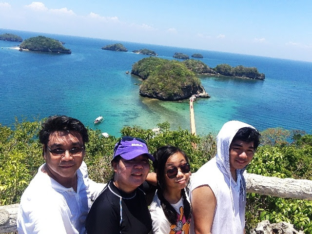
View of the other islands from the Governor island.
Some of the islands as seen from the viewing point on Governor Island.


Children's Island lives up to its name as its shallow waters are very suitable for small children.


Quezon Island can be considered as Hundred Islands’ activity center because among its many islands, this jam-packed bliss is the only place where you’ll see a lot different fun activities happening.


Marcos Island’s fantastic beach and natural swimming pool is a great combo for swimming enthusiasts.


    Imelda Cave on Marcos Island: A cathedral-shaped nature cave, it has two chambers, with the outer chamber accessible via a submerged opening from one side of the island and from an open ceiling which can also be reached by a 30-m trail from the beach area. One of the favorite things to do here is to dive from the tip of the wooden stairs and into the water. The cave which can be reached by swimming, kayaking or rafting is a corner of serene beauty on which one can just lay back and enjoy the quiet atmosphere.


This natural swimming pool inside the Imelda Cave is protected from the sunlight by the tunnel that houses it. Going down its wooden stairs won’t be much of an effort as it’s not very high. You would immediately feel the coolness inside this cave just half-way of entering it. Make sure to bring your life jacket if you’re not a good swimmer yet because every corner of this swimming pool is very deep.


Other Islands good for snorkling and just lying on its beach.
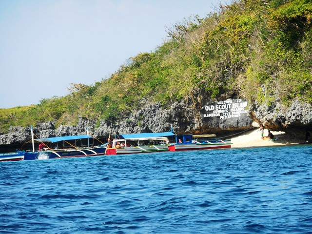
Old Scout Island:


Lopez Island:


Macapagal Island: (good for snorkling)


Romulo Island:


-wikipedia, wonderingwanderer


Tuesday, May 19, 2015

Bolinao, Pangasinan

Bolinao, Pangasinan

Bolinao is a third class municipality in the province of Pangasinan, Philippines. Folk etymology attributes the name "Bolinao" or this remote fishing enclave from the fish piece "monamon" but commonly called "Bolinao" by the Tagalogs, Bicolanos and the Visayans. A theory also points out that once upon a time "pamulinawen" trees grew luxuriantly along its shores, thus, the Ilocano migrants who crossed the Lingayen Gulf named it phonetically similar to the name of the tree. Nowadays, however, such tree does not exist anymore.

Unofficial records narrate the story of an Italian missionary named Blessed Odorico who said the first mass in Bolinao Bay, baptizing several locals while he was on his way to China. He took refuge in what is now known as Bolinao during a storm in 1324. Two centuries later, an account narrates the arrival of Juan de Salcedo and his crew reached Bolinao and chanced upon a Chinese Sampan who captured a native chieftain. Salcedo and his men liberated the natives and the latter immediately pledged vassalage to the King of Spain.

Bolinao challenged the historical fact that the first Mass was held on March 31, 1521, Easter Sunday, at Limasawa in Southern Leyte. Memorial markers (donated by Italian priest Luigi Malamocco, 62, from Odorico’s hometown of Friuli, Italy) were set in the town’s church and on Santiago Island, claiming that in 1324, Franciscan missionaries led by an Italian priest named Odorico celebrated a thanksgiving Mass thereat and also baptized natives.

The people generally speak Ilocano, Tagalog, Pangasinan, and their own unique native language called Bolinao. The Bolinao language is closely related to Sambalic. Bolinao was part of the province of Zambales from mid-18th and was turned over to Pangasinan in 1903.


Saint James The Great Parish Church:


The Saint James the Great Parish Church is a Spanish colonial church located at Brgy. Germinal in Bolinao, Pangasinan, Philippines. The church was made out of black coral stones. The church underwent series of natural and man-made calamities, such as the 1788 earthquake, 1819 fire incident, and Typhoon Emong in 2009.


Cape Bolinao Lighthouse:


Cape Bolinao LighthouseThe Cape Bolinao Lighthouse at Patar rises 351 feet (107 m) above sea level atop Punta Piedra Point, a towering hill of solid rock which is the sharp point of Cape Bolinao itself. It was built by the Americans in 1903 on a 351 feet (107 m) high promontory at the western part of Cape Bolinao, the lighthouse still sends signals to vessels passing by the area.

The lighthouse provides a panoramic view of a portion of the 1,269 hectare Cape Bolinao Dendro Thermal Ipil-Ipil Plantation on a land area where archaeological excavations have revealed relics from the 14th to the 15th centuries. Filipino, British and American engineers constructed the
lighthouse in 1905. According to the Bureau of Geodetic Surveys, the land elevation is 250 feet
(76 m). Visibility is 20 miles (32 km; 17 nmi) at midsea towards the lighthouse in Poro Point. The winding stairway has 6 platforms with 20 steps or rungs for a total of 120 steps plus 14 more to the illumination room, or an over-all total of 134 steps.


Treasures of Bolinao Beach Resort:


Treasures of Bolinao Beach Resort derived its name from the site of the main house which is sitting in the coral surrounded by the tranquility of nature. It is located in the heart of Cape Bolinao white beach, and the very first one in Bolinao that was accredited by Department of Tourism.


Treasures is overlooking the seemingly boundless China Sea. The water is so clean as you can see the crystal clear water with a rejuvenating power. Just behind the resort is the towering Cape Bolinao Lighthouse. On the left is the beach and in the background the rolling hills endowed with various fauna and flora. On the right the various sculpture like monuments of rock formations. All these locations are facing west so everyone can see the colors of the sunset.


Patar Beach:

Bolinao is known for a number of pristine beaches, the most popular of which is Patar Beach, situated on the western coast along the South China Sea southwest of the town proper.


Patar Beach is a creamy white sand beach that slopes gradually from shore making it good for swimming. It is a public beach. There are several more stretchers of white sandy beach with coral rock formations and small coves has you head further down south along the coast. This coastline includes stretches of nice beaches in the towns of Agno, Bani, Burgos and Dasol.


Enchanted Cave:
Enchanted Cave in Bolinao, Pangasinan is one of a couple of caves that are in the area.


 It looks to be a huge cave system but the Management restricts you from entering certain areas. These are clearly marked by ropes. Since some areas of the cave has a 10 to 20 drop. The area also has adequate lighting so one does not need a headlamp. A pair of goggles or a diving mask would be great to keep a lookout for sharp rocks on the cave floor, and also to take a peek down those deep cave tunnels.


The name itself portrays about its mystical beauty. When you enter the cave, you will be spellbound. You will definitely wonder about its formation. It is one of its kind caves that hold emerald green and fresh pool of water within its womb.


It also houses a trail of hundreds of corals that more look like rocks. According to local people and tour guides, millions of years ago Bolinao was under the sea due to the discovery of Fossilized giant clams around the area and formation of this pool is supposed to be the result of evolution.

It's a great place to relax because of the cool, fresh and clean water


El Pescador Beach Hotel:


El Pescador is a former village of fishermen way back on 1989, it was owned by Jesus Celeste until now. The coast has a vast variety of fish. Their catch was a stunning sign of marine life in Bolinao, until the fishermen starts to notice that the amount of their catch is getting smaller. then the fishing business of Jesus Celeste was set aside and shift the El Pescador to a village inn in 1992,


The inn did a humble beginning. It gained a lot of loyal customers through the years of its venture, because it is near the town proper. El Pescador never stops to grow and develop. Until it became a hotel with a friendly and a very humble service remained, until major town activities were held in El Pescador like beauty pageant, inductions, graduations etc.


-wikipedia, waypoints.ph, shoestringtravelers, outoftownblog